

General Information
| Languages : | English, Maori |
| Currency : | New Zealand Dollar (NZD) |
| Time Zone : | EST +17hrs |
| Capital City : | Wellington |
| Population : | 4 Million |
| Government : | Parliamentary Democracy |
| Total Area : | 103,737 mi² |
| Climate : | Temperate with sharp regional contrasts |
| National Holidays: | Waitangi Day , 6 February; ANZAC Day, 25 April |
| Additional Info: | New Zealand’s national symbol is a nocturnal flightless bird with nostrils on the end of its large beak called the Kiwi. |
Destination Activities
![]()
![]()
![]()
![]()
![]()
![]()
![]()
Activity Details
New Zealand is a country in the south-western Pacific Ocean comprising two large islands (the North Island and the South Island) and numerous smaller islands, most notably Stewart Island/Rakiura and the Chatham Islands. In Maori, New Zealand has come to be known as Aotearoa, which is usually translated into English as "The Land of the Long White Cloud". The Realm of New Zealand also includes the Cook Islands and Niue, which are self-governing but in free association; Tokelau; and the Ross Dependency (New Zealand's territorial claim in Antarctica). A common mistake is to allow insufficient time for a visit. (Since it's a long and expensive way to go for most people, many folks end up spending all their time in Australia and then wishing that they had spent an equal or longer time in this very variegated archipelago). Relax and allow at least three or four weeks for each island!
Rafting
Fox Glacier Township is on the West Coast of New Zealand's South Island, part of what is referred to as "Glacier Country". Fox Glacier Township is quieter than the area near the Franz Josef Glacier. 20 minutes north of Franz Josef are two of the best one-day whitewater rafting runs anywhere on the planet. The most popular one-day heli-rafting trips are the Class IV Whataroa River and the Class V Perth River, both just 25 minutes north of Franz Josef Glacier.
The Whataroa River's source is in the Southern Alps and it flows north and northwest, passing the township of Whataroa on the eastern side before reaching the Tasman Sea just south of Abut Head. Access to the upper reaches of the river for rafting is either via hiking or helicopter. Distinctive deep green water has carved its way through three dramatic gorges. Rafts provide the perfect means to explore these incredible canyons. Set amongst the most amazing river scenery you can imagine and combined with awesome whitewater, the Whataroa is a must-do for anyone looking to raft the best whitewater in New Zealand, or in the world! Guides love this river because the scenery is so spectacular and the rapids are so enjoyable. For a one day heli-rafting trip, expect to pay NZ$375 per person ($285, Nov 2007 exchange rate).

The Perth River's source is in terrace icefields north of the Rangitata Divide and is joined by multiple tributaries, including a creek from Abel Lake. It features a number of rapids and passes through two gorges before meeting the Whataroa River. The river is largely inaccessible, but recently, adventure tourism companies have begun offering heli-rafting on the river. The normal rafting put in at Five-Finger stream gives a nice class III-IV run with one amazing gorge. By flying up to Scone Hut, the trip becomes one of the best IV-V runs on the coast. More recently paddlers have been flying or walking upstream of scone hut for some V-V+ excitement. The Perth River is relatively unknown at present, because rafting is so new on the West Coast. Those fortunate enough to have ventured through the limestone gorges of this remarkable river rate the Perth as an unbelievable experience. The alpine scenery is absolutely stunning, combined with lush green rainforest and aqua blue water. The rapids are world class and will thrill the most seasoned rafter. The Perth is a serious undertaking, so you must be physically fit and you must be able to swim to participate. For a one day heli-rafting trip, expect to pay NZ$395 per person ($298, Nov 2007 exchange rate). Other options are to hike up the valley and camp over night ready to embark on the white water experience in the morning.
Scuba Diving
An unexpected fact is that this small country's deeply indented coastline is as long as that of the United States. Nowhere in New Zealand is more than 81 miles from the sea, so it is no wonder that it has more scuba divers per capita than any other country in the world. Sea conditions are at their best in summer and autumn (January-June), when the weather is settled, underwater visibility is good and marine life is abundant. Coastal waters teem with colourful, fascinating sea life and the usually clear waters make for excellent viewing. The country abounds with sub-tropical reefs, wrecks, clear water springs and alpine fiords.
One of the most unique New Zealand dive sites is the crystal-clear waters of the Poor Knights Islands Marine Reserve. With its incredible range of fish, including many tropical species, it was considered by the late Jacques Cousteau to be one of the world's top diving locations. The Poor Knights Islands are a group of uninhabited islands off the east coast of the Northland Region of the North Island of New Zealand. They are located 31 miles to the northeast of Whangarei, and lie 14 miles offshore half way between Bream Head and Cape Brett. The islands are a popular diving location due to the variety of marine fauna found there, and are popular also for their intriguing landforms, which include natural arches and caves. This subtropical reef system presents a stunning diversity of reef fish, pelagics, sponges, anemones, nudibranchs and sea weeds. The Poor Knights can be dived all year round. The underwater visibility varies from between 50-100ft throughout the year, although at times visibility exceeding 150ft can be experienced, with the best visibility during the winter months of May to September. Water temperatures range from 66-77 degF during the summer months to 57-62 degF during winter. Most divers use a 7mm wetsuit year round.
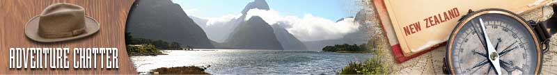
Fiordland is a geographic region of New Zealand that is situated on the south-western corner of the South Island. Most of it is covered by the Fiordland National Park, the largest national park in New Zealand and one of the larger parks in the world. Most of Fiordland is dominated by the Southern Alps and its ocean-flooded, steep western valleys. Situated within Fiordland are Browne Falls and Sutherland Falls, which rank among the tallest waterfalls in the world. The underwater environment in the fiords is one of the most intriguing and unique in the world. This is not only because of the beautiful natural environment and the marine reserves that exist here, but also because of an interesting effect of the high rainfall in the area. As rainfall drains through the lush forests it becomes stained with tannins until it is the color of strong tea. This dark freshwater does not mix with the seawater of the fiords but rather it sits on top, limiting the amount of light that reaches into the depths. As a result light sensitive species that normally live at great depths are found much closer to the surface in Fiordland waters. This gives divers, as well as visitors to the Underwater Observatory, the opportunity to see rare species such as the red and black corals at relatively shallow depths. Warm water species include splendid perch and blue-dot triplefin. Cool water species include copper moki, trumpeter, banded wrasse and pigfish. Species usually confined to deep water (328ft+ include sandpaper fish and spiny sea dragons.
Climbing
New Zealand is a fantastic location for mountaineering; it was the training ground for Sir Edmund Hillary, one of the first two people to climb Mt Everest.
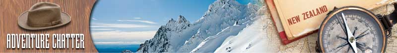
The South Island is the largest land mass of New Zealand, and is divided along its length by the Southern Alps, the highest peak of which is Aoraki/Mount Cook at 3,754m (12,320 ft). There are eighteen peaks over 3,000m (10,000 ft) in the South Island. The North Island is less mountainous than the South, but is marked by volcanism. The highest North Island mountain, Mount Ruapehu (2,797m / 9,177ft), is an active cone volcano. The dramatic and varied landscape of New Zealand has made it a popular location for the production of television shows and films, including the Lord of the Rings trilogy and The Last Samurai.
Aoraki/Mount Cook<br>
This mountain is in the Aoraki/Mount Cook National Park. Aoraki means "Cloud Piercer". The park contains more than 140 peaks standing over 2,000 m (6,500 ft) and 72 named glaciers, which cover 40% of the park's 173,000 acres. The settlement of Mount Cook Village (also known as The Hermitage) is a tourist centre and base camp for the mountain. It is 7 km from the end of the Tasman Glacier, 12 km south of Aoraki/Mount Cook's summit. On 25 December 1894, New Zealanders Tom Fyfe, James (Jack) Clarke and George Graham, all from the South Island town of Waimate, successfully reached the summit via the Hooker Valley. Swiss guide Matthias Zurbriggen climbed the mountain solo very shortly afterwards from the Tasman Glacier side, via the ridge that now bears his name.


It remains a challenging ascent, with frequent storms and very steep snow and ice climbing to reach the peak. Strictly speaking, it is a triple peak, with the north peak being the highest.
Mount Aspiring
Mount Aspiring is New Zealand's highest mountain outside the Mount Cook region. Set within the South Island's Mount Aspiring National Park, it has a height of 3,033m (9,950ft). It is also often called 'the Matterhorn of the South,' for its pyramidal peak when seen from the Dart River. It was first climbed in 1909 by Major Bernard Head. Mt Aspiring sits slightly to the west of the main divide, 18 miles west of Lake Wanaka. It lies at the junction of three major glacial systems - the Bonar Glacier, which drains into the Waipara River, and the Volta and Therma Glaciers, which both drain into the Waitoto River. The peak is usually accessed via the West Matukituki Valley, which is reached by a 31-mile road from Wanaka to a trailhead at Raspberry Flat. From here a network of huts provide staging points for climbers. The first is Mt Aspiring Hut, which is 5 miles (or approximately two hours' walk) from the trailhead.
Hiking
New Zealand has a number of national parks and other wilderness and forested areas, much of which is managed by the Department of Conservation. The activity known in other countries as hiking, trekking or bushwalking is known as tramping in New Zealand and is a very popular activity for visitors and locals.
New Zealand has a number of 'Great Walks', which are very well maintained, cover some of the most beautiful scenery, and in the peak season, can be quite busy, requiring bookings with DOC well in advance. Some of these are detailed below:
The Milford Track, (about 4 days) which runs from Lake Te Anau through the McKinnon pass in the Southern Alps, leading out to Milford Sound. The Milford Track is New Zealand's most famous tramping route and is one of the most famous walking tracks in the world. It is located in stunning scenery amidst mountains and temperate rain forest in Fiordland National Park in the southwest of the South Island. The track spans a distance of 33 miles starting at the head of Lake Te Anau and finishing at Milford Sound at Sandfly Point. The Lake Te Anau end of the track can be reached either by a ferry, or by climbing over Dore Pass from the Milford Sound road. Sandfly Point can only be reached by the sea, either sea kayaking or the regular ferry which runs for trampers during the peak season. Due to its fame, and its enormous popularity, the Milford is also one of the most highly regulated walking tracks in the world. During the summer peak season of late October to late April, access to the trail is highly regulated. Walkers must complete the track in four days, traveling only in the northward direction. Camping is prohibited on the trail. Walkers can tramp the track independently, or as part of a more expensive guided walk with a guide company. A maximum of 90 walkers can start the trail per day (40 Independent, and 50 Guided). Usually these 90 places are booked out for many months in advance, despite the high cost of the guided walks. During the off season from May to mid-October, the track is essentially unregulated, and can be tramped in either direction, over any number of days. It is however much more difficult and dangerous tramping in this season, as facilities at huts are removed, some bridges are removed to prevent damage, and numerous avalanche paths cross the track.

The Routeburn Track, (about 3 days). The Routeburn Track is a world-renowned tramping track found on the South Island of New Zealand. The track is usually completed by starting on the Queenstown side of the Southern Alps, at the northern end of Lake Wakatipu, and finishing on the Te Anau side, at the Divide, several miles from the Homer Tunnel to Milford Sound. The track overlaps two National Parks; the Mount Aspiring National Park and Fiordland National Park's with the border being Harris Saddle. This area gets much less rain than the Milford Sound, and the forests are very different, especially on the eastern side of the saddle, where there are a lot of large pines and other trees, and relatively few ferns. The track spends a long time on the high ridges around Harris Saddle, with great long distance views in many directions.
The Heaphy Track on the northern tip of the South Island. This is a popular tramping track in the north west of the South Island of New Zealand. It is located within the Kahurangi National Park and classified as one of New Zealand's 10 Great Walks by the Department of Conservation. Named after Charles Heaphy, the track is 51 miles long and is usually walked in four or five days.
The Rakiura Track, on Stewart Island: This track is an 18-mile tramping track located on Stewart Island. It is one of the New Zealand Great Walks. It generally follows the coastline for a large part of its length, passing small inlets, large bays and mudflats, before crossing steep hills covered in bush (dense forest) during its middle section.
Tongariro Northern Circuit, which passes through the central North Island's volcanic plateau. This is a three to four day tramp in Tongariro National Park. Part of it is the famous Tongariro Alpine Crossing, a day's march that incorporates the Northern Circuit's most stunning scenery. The complete trail forms a 31-mile long loop trail that circumnavigates Mount Ngauruhoe. Approximately 7,000 trampers complete the walk each year. This compares to the approximately 25,000 who walk only the Tongariro Crossing section.
Biking
Information on Cycling
You can bring your own bike, as well as hire a bike in some of the larger cities. You must wear a helmet while riding, otherwise you may be fined. When hiring a bike you should be supplied with a helmet. Also remember to ride on the left. Riding bikes in New Zealand can be fun, but be aware of (tourist) buses and trucks on main highways as overtaking distances can be slim. You should also be prepared for the large distances between towns and cities and the generally windy weather. While some areas of New Zealand are flat, most tourists cycling in New Zealand will find that they need to be able to cope with long periods of cycling up hills, especially in the Coromandel. Christchurch has the largest number of guided and self-guided tour operators and there are a number of bike rental companies based there also.
Being a temperate coastal climate, the weather is changeable and it is recommended that cyclists have all options covered. It is often said that in New Zealand you can get four seasons in one day, particularly in the high country. Due to ozone depletion above NZ and Australia, burn times in the summer are often shorter relative to elsewhere in the world, and a factor 15 or greater sunscreen is essential to avoid the discomfort (and danger) of sunburn.
Where to Cycle
The Otago Central Rail Trail is a 90-mile walking, cycling or horse riding track in the South Island of New Zealand. It runs in an arc between Middlemarch and Clyde, along the route of the former Otago Central Railway.
To enjoy the scenery, the engineering involved in building the railway and the towns and people along the way, allow 3-5 days to cycle it. The Trail starts at 650ft above sea level in Middlemarch and rises to its highest point of 2,027ft between Ranfurly and Oturehua. On the journey it passes through three tunnels and over several large viaducts. A flashlight is advised for the tunnels. The Trail is well maintained and signposted. Toilets are available at several points on the Trail and the contour is best described as easy. The trail passes through or past several small towns. Mountain bikes can be rented from outlets in Middlemarch, Ranfurly, Alexandra and Clyde. Some of these cycle shops will also provide transport for riders and bikes, and will move luggage. The trail is very popular, and accommodation should be booked well in advance during busy periods such as long weekends and holidays.
The manager of the Rail Trail, the Otago Central Rail Trail Charitable Trust has a website and publishes a leaflet that provides detailed information on the route, and advertisements for businesses providing services to users of the trail. There are visitor information centers in Alexandra, Cromwell, Roxburgh, Ranfurly and Dunedin. Several books on the Rail Trail and the surrounding area can also be purchased at retail bookshops thorought New Zealand. These include, Guide to the Otago Central Rail Trail, Illustrated History of Central Otago & the Queenstown Lakes District, Guide to the Otago Goldfields Heritage Trail, Otago Central Rail Trail - A Pictorial Journey. All are written by Gerald Cunningham and published by Reed Publishing.
The Little River Rail Trail is a cycling and walking track established near Little River on the Banks Peninsula in the Canterbury region of New Zealand's South Island. It can be considered similar to the popular and longer Otago Central Rail Trail. It utilizes the formation of the Little River Branch railway that ran from a junction with the Southbridge Branch in Lincoln to Little River. The railway line closed on 30 June 1962 and the formation had remained in situ, remarkably undisturbed, until the early 2000s, when an organization was formed to revitalize it for public use.
On 28 May 2006, the first section of the rail trail was opened, between Motukarara and Catons Bay Reserve. It has since been extended to the Little River hotel, some 2,600ft short of the restored Little River station, which has preserved ex-New Zealand Railways freight wagons and a craft center. The second section between Prebbleton and Lincoln (4.5 miles) opened on 30 November 2006. This section is an offroad track adjacent to the old railway line that runs alongside Birchs Road.
Photography


If you have adventure-travel related experience in this region and would like to add content to this page, please contact us to learn how.