

General Information
| Languages : | Spanish, Quechua, Aymara |
| Currency : | Boliviano (BOB) |
| Time Zone : | EST +1hrs |
| Capital City : | La Paz |
| Population : | 9 Million |
| Government : | Republic |
| Total Area : | 424,164 mi² |
| Climate : | Varies with altitude; humid and tropical to cold and semiarid |
| National Holidays: | Independence Day, 6 August |
| Additional Info: | Home to the highest natural lake in the world, Lake Titicaca, and the highest altitude capital city, La Paz. 70% of the population still lives according to traditional ways, so this is a place that is alive with festival and ceremony. |
Destination Activities
![]()
![]()
![]()
![]()
![]()
Activity Details
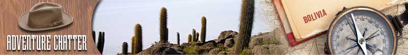
Bordered by Brazil on the north and east, Paraguay and Argentina on the south, and Chile and Peru on the west, Bolivia has been a landlocked nation since it lost its coastal department of Litoral to Chile in the War of the Pacific. However, it does have access to the Atlantic via the Paraguay River. Its western highlands are situated in the Andes Mountains and include the Bolivian Altiplano. The eastern lowlands include large sections of Amazonian rainforests and Chaco. The highest peak is Nevado Sajama at 6,542m (21,463 ft) located in the department of Oruro. Lake Titicaca is located on the border between Bolivia and Peru. The Salar de Uyuni, the world's largest salt flat, lies in the southwest corner of the country, in the department of Potosi.
Trekking
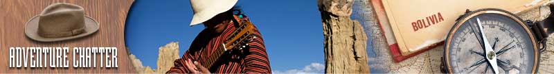
There is a lot of excellent trekking country in Bolivia. The crown jewel of the Bolivian Andes is the Cordillera Real, a fabulous wilderness of massive blue-white glaciers tumbling from 20,000ft snowy peaks that hold sway over amazing alpine valleys with sparkling lakes. A great trek is to make your way beneath some of the highest peaks of the Cordillera Real, and encounter remote Indian villages where you can meet descendants of the Incas and Aymaras who seldom see visitors from the outside world. You can also visit Tiahuanaco, Bolivia's most important archaeological site, and enormous Lake Titicaca, legend-filled birthplace of the first Inca king. There are several organized treks in this area with various length itineraries available - a popular length of time being 3 weeks. Most treks include some time at Like Titicaca to get acclimatized to the altitude before starting the trek. Treks will take you along high trails. Expect to see a great diversity of scenery, including lovely alpine valleys with picturesque lakes, snow-capped peaks and scattered Quechua Indian villages. Bolivia is the jewel in the crown of the Andean countries, with its spectacular landscapes, fascinating history and the friendliest people in South America.
Climbing
Lake Titicaca sits 3,812m (12,507ft) above sea level making it the highest commercially navigable lake in the world. A great way to explore this lake is by kayak - explore Isla del Sol and the historic lakeside town of Copacabana whilst camping beneath the stars of the southern hemisphere. Copacabana is the main Bolivian town on Lake Titicaca, from where boats leave for Isla del Sol, the sacred Inca island. The town has a large 16th-century shrine, the Basilica of Our Lady of Copacabana. Our Lady of Copacabana is the patron saint of Bolivia. Copacabana's religious celebrations, cultural patrimony, and traditional festivals are well known throughout Bolivia.
Madidi is a national park in the upper Amazon River basin in Bolivia. Ranging from the glacier-covered peaks of the high Andes Mountains to the tropical rainforests of the Tuichi River, Madidi and its neighbors are recognized as one of the planet's most biologically diverse regions. The local people speak the Quechua language, and have built rudimentary bridges across some of the rivers. Some eco-lodges are found in and around the Madidi National Park. The oldest and best known is Chalalan Ecolodge in Chalalan on the Tuichi River. Another is the San Miguel del Bala Eco-Lodge on the banks of the Beni River, reached by boat 40 minutes up stream from Rurrenabaque.
Noel Kempff Mercado National Park is a national park in the north-eastern portion of the Santa Cruz Department, Bolivia, on the border with Brazil. This is one of the most biologically diverse areas in the world. In the area of Santa Cruz de la Sierra the weather is very humid and warm. In this area near the border of Brazil, there are a lot of Rainforests and Tropical animals. The normal temperature is between 77 and 84 deg F. The rainfall is annually, roughly 60-in. This park spreads up on a great part of the Caparuch or Huanchaca plateau. The great waterfalls and the mountain ranges make the place of great interest for eco-tourism - outstanding is the orchid bay, the lookout of the monkeys, the Caparuch plateau and the Rainbow waterfalls.
Amboro National Park in central Bolivia is a nature reserve with over 800 species of birds, over 125 mammalian species including puma, ocelots, and the rare Spectacled Bear. The Spectacled Bear is adapted to the rainforest as it has a very keen sense of smell and a large nose for finding food in small soil crevices and in high tree canopies. It also has sharp, elongated claws for digging root systems and uprooting plants. The park is in the western part of Santa Cruz Department, at the "Elbow of the Andes", where the eastern cordillera bends slightly westward from its north course. Amboro National Park lies within three distinct ecosystems: the foothills of the Andes, the northern Chaco, and the Amazon Basin. The peculiar features of the geography of the park determined the biological makeup, allowing the development of a great variety of flora and fauna.
Carrasco National Park in Cochabamba - In this area one can appreciate a mountainous landscape of great beauty with deep valleys and canyons, torrential rivers and waterfalls, as well as exuberant vegetation. Among the main attractions: Vida Silvestre Sanctuary that includes the Caverns of the Repechon, two caverns with guacharos birds and one with bats, the natural puddles in the San Rafael and San Mateo rivers, the ruins of Incachaca.
Ecotourism
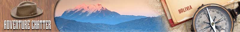
Nevado Sajama is an extinct stratovolcano and the highest peak in Bolivia. The mountain is located in Sajama National Park in the southwest area of the country some 10-15 miles from the border with Chile. The peak is an isolated cone, but is geologically complex, with lava domes of andesitic and rhyodactic composition overlain by an andesitic stratovolcano. The date of the most recent eruption is uncertain, although Holocene activity is assigned to the volcano by many. Sajama lacks the history, location, beauty and overall appeal of Illimani. As a result, it is less often climbed.
Cordillera Real is a granite range of fold mountains east of the Bolivian capital of La Paz, measuring 78 miles in length and 12 miles in width. There are six summits higher than 6,000m (19,685ft) in the cordillera which are from north to south: Pico del Norte (6,070m), Illampu (6,368m), Ancohuma (6,427m), Chachacomani (6,074m), Huayna Potosi (6,088m), and Illimani (6,462m).
Illimani (from Aimara, meaning "golden eagle") is the highest peak in the Cordillera Real. It lies just south of La Paz at the eastern edge of the Altiplano. It is the second highest peak in Bolivia and the eighteenth highest peak in South America. The snow line lies at about 4,570m (15,000ft) above sea level, and glaciers are found on the northern face at 4,983m (16,350ft). The mountain has four main peaks; the highest is the south summit, Nevado Illimani, which is a popular ascent for mountain climbers. The current standard route on the mountain climbs the west ridge of the main summit. This route usually requires four days, where the summit is reached in the morning of the third day.
To the native Aymara Indians the great peaks are cautiously revered. Evil spirits are presumed to lurk on-high, their wrath appeased by offerings and sacrifice. Illimani is especially viewed with awe. Given its massive triple peak structure; isolation from peaks in its immediate surround; and its considerable height, it is little wonder that Illimani has for centuries held particular respect among the native peoples.
Photography


If you have adventure-travel related experience in this region and would like to add content to this page, please contact us to learn how.