General Information
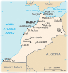
| Languages : | Arabic (official), Berber dialects |
| Currency : | Moroccan Dirham (MAD) |
| Time Zone : | EST +5hrs |
| Capital City : | Rabat |
| Population : | 33 Million |
| Government : | Constitutional Monarchy |
| Total Area : | 172,413 mi² |
| Climate : | Mediterranean, becoming more extreme in the interior |
| National Holidays: | Throne Day (accession of King MOHAMED VI to the throne), 30 July |
| Additional Info: | Land of two seas, the variety of beaches is infinite. Morocco is filled with history with its palaces and monuments. Moroccan cuisine is like the country: rich in flavors, smells and colors. It is known worldwide for its sweet and sour combinations and its use of spices: saffron, cumin and coriander. A Moroccan meal is an experience that appeals to the senses. |
Destination Activities
Activity Details
Biking
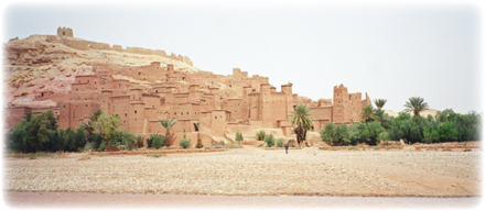
The Kasbah Trail: A Kasbah or Qassabah is a unique kind of medina, Islamic city, or fortress. Try cycling this trail in southern Morocco - the land of extreme contrasts, from the Kasbahs and lush oases of the Draa Valley, to the high peaks and hidden valleys of the Atlas Mountains or the sand dunes of Erfoud. Traffic is minimal, road surfaces are good and the winter climate is ideal for this kind of trip.
The Nomad Trail: Sandwiched between the snowcapped High Atlas Mountains to the north and the Sahara to the south, this is another great trail with vivid contrast and unique beauty. Follow part of the great trade route to Timbuktu down the spectacular Draa oasis, a wealth of color, to where the river disappears into the sands of the Sahara. Ride through villages of mud-baked buildings, sand colored Kasbahs and remote valleys where time has stood still and nomads tend to their flocks of sheep and goats.
Trekking
Jbel Toubkal is a mountain peak in southwestern Morocco. At 13,670ft, it is the highest peak in the Atlas Mountains and in North Africa. It is 39 miles south of the city of Marrakech, in the Toubkal National Park.
Trekkers usually approach the mountain from the road-end village of Imlil. Qualified local guides can be hired, as well as mules and porters, to carry equipment and food supplies higher into the mountains. For experienced mountaineers, guides are not required for the normal route, as it is an easy hike and orientation is not a problem. Usage of the mules is questionable, as they are often being overloaded and mistreated, and there is no need to carry food or tents if you stay in the refuge.
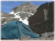
The normal route starts with easy walk to the village of Aroumd. Past Aroumd a floodplain is crossed and route follows the left slope of the valley southwards. The valley bends to the east to the tiny settlement of Sidi Chamharouch, which has grown around a Muslim shrine. At Sidi Chamharouch path leads over the stream and steeply uphill to the right side of the Isougouane valley which leads to two stone-built refuges (old Neltner Refuge and new Refuge du Toubkal) that are often used as base camp at 3,207m. It is possible to buy good meals in the Refuge du Toubkal. Tent can be pitched near the refuges for a small charge.
From that point a path crosses the stream, climbs a steep scree slope to the east and enters a valley (corrie), then climbs another steep slope to reach a col (Tizi'n'Toubkal at 3,940m). At the col the route turns left (northwards) to the summit ridge of Jbel Toubkal. The 4,167m summit is crowned with a curious pyramidal metal frame and views take in most of the Atlas and Anti-Atlas Mountains.
The ascent during the summer (from May) is non-technical and easy, only complicated by steep and slippery scree slopes and altitude sickness. Sturdy boots and proper (windproof) clothing is required, trekking poles are helpful on the scree. An ice-axe may be needed on the remaining snowfields in the early summer.
It is possible to climb the mountain in two days - first day up to the refuge (around seven hours without mules), second day to the summit (around five hours) and back to Imlil (up to five hours).
In summer the mountains can be very dry, but are sometimes subjected to storms. Although the temperature should keep above zero during the day, freezing conditions are possible over 3,500m. In winter the mountains are covered in snow and ice, and can be prone to avalanches. Skiing is possible as the snow can lie to considerable depth and cover many rocky slopes. Information about state of the route can be obtained at Marrakech tourist offices or at Imlil.
Photography
If you have adventure-travel related experience in this region and would like to add content to this page, please contact us to learn how.


