

General Information
| Access Country : | Nepal, Tibet - China |
Destination Activities
![]()
![]()
![]()
Activity Details
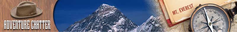
Mount Everest, also called Chomolungma or Qomolangma or Sagarmatha, is the highest mountain on Earth, as measured by the height of its summit above sea level. The mountain, which is part of the Himalaya range in High Asia, is located on the border between Nepal and Tibet, China. By the end of the 2006 climbing season there had been 3,050 ascents to the summit by 2,062 individuals, and at least 630 more ascents in 2007. There have been more than 200 deaths on the mountain, where conditions are so difficult that most corpses have been left where they fell; some are visible from standard climbing routes.
Mountaineering / Climbing
Climbers range from experienced mountaineers to relative novices who count on their paid guides to get them to the top. This means climbers are a significant source of tourist revenue for Nepal, whose government also requires all prospective climbers to obtain an expensive permit, costing up to $25,000 per person.
Mount Everest has two main climbing routes, the southeast ridge from Nepal and the northeast ridge from Tibet, as well as many other less frequently climbed routes. Of the two main routes, the southeast ridge is technically easier and is the more frequently-used route. It was the route used by Edmund Hillary and Tenzing Norgay in 1953 and the first recognized of fifteen routes to the top by 1996. This was, however, a route decision dictated more by politics than by design as the Chinese border was closed to foreigners in 1949. Reinhold Messner (Italy) summited the mountain solo for the first time, without supplementary oxygen or support, on the more difficult Northwest route via the North Col to the North Face and the Great Couloir, on August 20 1980. He climbed for three days entirely alone from his base camp at 6,500m. This route has been noted as the 8th climbing route to the summit.
Most attempts are made during May before the summer monsoon season. A change in the jet stream at this time of year reduces the average wind speeds high on the mountain. While attempts are sometimes made after the monsoons in September and October, the additional snow deposited by the monsoons and the less stable weather patterns makes climbing more difficult.
Southeast ridge
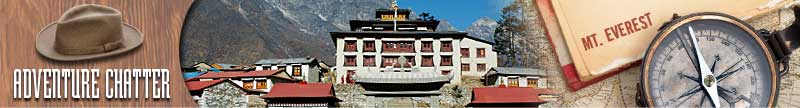
The ascent via the southeast ridge begins with a trek to Base Camp at 5,380m (17,600ft) on the south side of Everest in Nepal. Expeditions usually fly into Lukla (2,860m) from Kathmandu and pass through Namche Bazaar. Climbers then hike to Base Camp, which usually takes six to eight days, allowing for proper altitude acclimatization in order to prevent altitude sickness.
Climbing equipment and supplies are carried by yaks, dzopkyos (yak hybrids) and human porters to Base Camp on the Khumbu Glacier.
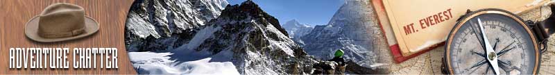
 Khumbu Icefall
Climbers will spend a couple of weeks in Base Camp, acclimatizing to the altitude. During that time, Sherpas and some expedition climbers will set up ropes and ladders in the treacherous Khumbu Icefall. Seracs, crevasses and shifting blocks of ice make the icefall one of the most dangerous sections of the route. Many climbers and Sherpas have been killed in this section. To reduce the hazard, climbers will usually begin their ascent well before dawn when the freezing temperatures glue ice blocks in place. Above the icefall is Camp I at 6,065m (19,900ft).
From Camp I, climbers make their way up the Western Cwm to the base of the Lhotse face, where Camp II or Advanced Base Camp (ABC) is established at 6,500m (21,300ft). The Western Cwm is a relatively flat, gently rising glacial valley, marked by huge lateral crevasses in the center which prevent direct access to the upper reaches of the Cwm. Climbers are forced to cross on the far right near the base of Nuptse to a small passageway known as the "Nuptse corner". The Western Cwm is also called the "Valley of Silence" as the topography of the area generally cuts off wind from the climbing route. The high altitude and a clear, windless day can make the Western Cwm unbearably hot for climbers.
From ABC, climbers ascend the Lhotse face on fixed ropes up to Camp III, located on a small ledge at 7,470m (24,500ft). From there, it is another 500m to Camp IV on the South Col at 7,920m (26,000ft). From Camp III to Camp IV, climbers are faced with two additional challenges: The Geneva Spur and The Yellow Band. The Geneva Spur is an anvil shaped rib of black rock named by a 1952 Swiss expedition. Fixed ropes assist climbers in scrambling over this snow covered rock band. The Yellow Band is a section of sedimentary sandstone which also requires about 100m of rope for traversing it.
On the South Col, climbers enter the death zone. Climbers typically only have a maximum of two or three days they can endure at this altitude for making summit bids. Clear weather and low winds are critical factors in deciding whether to make a summit attempt. If weather does not cooperate within these short few days, climbers are forced to descend, many all the way back down to Base Camp.

From Camp IV, climbers will begin their summit push around midnight with hopes of reaching the summit (still another 1,000m above) within 10 to 12 hours. Climbers will first reach "The Balcony" at 8,400m (27,700ft), a small platform where they can rest and gaze at peaks to the south and east in the early dawn light. Continuing up the ridge, climbers are then faced with a series of imposing rock steps which usually forces them to the east into waist deep snow, a serious avalanche hazard. At 8,750m (28,700ft), a small table-sized dome of ice and snow marks the South Summit.
From the South Summit, climbers follow the knife-edge southeast ridge along what is known as the "Cornice traverse" where snow clings to intermittent rock. This is the most exposed section of the climb as a misstep to the left would send one 2,400m (8,000ft) down the southwest face while to the immediate right is the 3,050m (10,000ft) Kangshung face. At the end of this traverse is an imposing 12m (40ft) rock wall called the "Hillary Step" at 8,760m (28,750ft).
Hillary and Tenzing were the first climbers to ascend this step and they did it with primitive ice climbing equipment and without fixed ropes. Nowadays, climbers will ascend this step using fixed ropes previously set up by Sherpas. Once above the step, it is a comparatively easy climb to the top on moderately angled snow slopes - though the exposure on the ridge is extreme especially while traversing very large cornices of snow.
After the Hillary Step, climbers also must traverse a very loose and rocky section that has a very large entanglement of fixed ropes that can be troublesome in bad weather. Climbers will typically spend less than a half-hour on "top of the world" as they realize the need to descend to Camp IV before darkness sets in, afternoon weather becomes a serious problem, or supplemental oxygen tanks run out.
Photography


If you have adventure-travel related experience in this region and would like to add content to this page, please contact us
to learn how.