

General Information
| Languages : | Spanish |
| Currency : | Chilean Peso (CLP) |
| Time Zone : | EST +1hrs |
| Capital City : | Santiago |
| Population : | 16 Million |
| Government : | Republic |
| Total Area : | 292,260 mi² |
| Climate : | Temperate; desert in north; Mediterranean in central region; cool and damp in south |
| National Holidays: | Independence Day, 18 September |
| Additional Info: | Chile is one of the world's most seismically active regions, from north to south. At any point amidst its diverse geography, you are bound to encounter a bubbling hot spring. The national dance is the cueca. |
Destination Activities
![]()
![]()
![]()
![]()
![]()
![]()
![]()
»»» Check out Special Destination: Patagonia
»»» From Chile many tours depart to Destination_Antarctica
Activity Details
Trekking
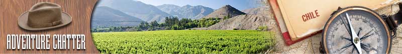
A long and narrow coastal Southern Cone country on the west side of the Andes Mountains, Chile stretches over 2,880 miles north to south, but only 265 miles at its widest point east to west. This encompasses a remarkable variety of landscapes.
In central Chile, try out the seldom trekked route of the "Condor Circuit". The entire circuit can take 8 to 10 days although there are some shorter routes (like the "Mondaca Trail" or the "Enladrillado Trail"). Delightful landscapes await trekkers on this circuit, which so far only a few have hiked fully. The Condor Circuit which forms part of the "Huaso Trails" network leads through thick forests and wild rivers, past lakes, glaciated mountains and active volcanoes. It is recommended that you hire guides and pack horses. Parts of this tour include hikes through pure wilderness where you are unlikely to meet other trekkers, which is why detailed planning is recommended.
In Chile's Lake District, you will find many trekking opportunities in this rich and varied area. Conguillio National Park is located in the Andes, in the provinces of Cautin and Malleco, in the Araucania region of Chile. Among the attractions in the park are the Llaima volcano, Sierra Nevada and wild landscapes characterized by islands of vegetation completely surrounded by vast areas of basaltic to andesitic lava flows. The park was used as the filming location for Walking with Dinosaurs, a television series produced by the BBC. The combination of green woods struggling for survival amidst the recent lava flows, together with the formation of lakes by continuous lava flows, creates an incomparable landscape where one can see the continuous changes of an Earth that is still alive.
Robinson Crusoe Island is the largest island of the Chilean Juan Fernandez archipelago in the South Pacific Ocean. The archipelago is made up of three islands, Robinson Crusoe, Alejandro Selkirk and the small Santa Clara. The island has a mountainous and undulating terrain, formed by ancient lava flows which have built up due to numerous volcanic episodes. The highest point on the island is 916m (3,005ft) above sea level, achieved by El Yunque. Intense erosion has resulted in the formation of steep valleys and ridges. A narrow peninsula is formed in the southwestern part of the island called Cordon Escarpado. September and October are very windy, and for this very reason, sometimes small airplanes cannot land on it. The best time to go there is from the second week of November until the end of March. The island is almost entirely a National Park, so touring it has a fee. The ticket costs about US$ 6 and is valid for a week.

And of course there is always Patagonia which spreads over the southern part of Chile.
Climbing
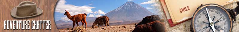
The Altiplano, where the Andes are at their widest, is the most extensive area of high plateau on earth outside of Tibet. It is an area of inland drainage lying in the central Andes, occupying parts of Chile, Argentina, Bolivia, Peru and Ecuador. Its height averages about 3,300m (11,000ft). The Altiplano is dominated by the massive peaks of active volcanoes to the west. The Atacama Desert, the driest area on the whole planet, lies to the southwest of the Altiplano. It's a great place to plan a trekking trip - from its summits you will behold the desolate landscape, the numerous "salares" (salt lagoons), the flamingo lakes and the peaks of salt. The climbs are, as a rule, technically easy, but due to the high altitude they require a very good physical condition. With a few exceptions, the remote points where the tours start from require private transport. The Chilean summer season (from December to February) is not very advisable for these tours, because of the heavy rains in the Atacamean Andes at this time of year.
» Ojos del Salado is a massive stratovolcano and the highest volcano in the world at 6,891m (22,608ft). It is also the second highest mountain in the Western Hemisphere and the highest in Chile. It is located about 370 miles north of Aconcagua, the highest mountain in the Western Hemisphere at 6,962 m (22,841 ft). There are two summit peaks; one, which is slightly higher but by no more than a meter, is known as the "Chilean summit"; the other, which is more substantial, is known as the "Argentine summit". These are so named because they are usually climbed from the Chilean and Argentine sides respectively, although the international border passes over both peaks. There is a short distance but steep and dangerous drop between the two peaks, so it is unusual for climbers to reach them both. The mountain climber will find wonderful landscapes and practically untouched nature. Some sources allude wrongly to the Atacama Desert to describe its location, but the frequent snowfalls, even in the middle of the summer, prove that the high Andean plateau, or altiplano, has a different climate than the distant desert. The best time of the year to its ascent is between November and April.
» Guallatiri is one of the most active volcanoes in northern Chile. It lies just west of the border with Bolivia and at the southwest end of the Nevados de Quimsachata. It is a symmetrical 6,071m (19,917ft) high ice-clad stratovolcano. Guallatiri's active vent is situated at its southern side. At approximately 5200m (17,060ft), the track becomes impassable by car, because of the rocks strewn all over it - time to make it on foot. The path divides up into different directions. Take the bottom one to the east up to where it ends. From there walk up the slope without taking any particular route. In the high season, stone marks and footprints make it easy to find the way. You will cross two other paths, the last one at approximately 5380 m. The best choice is to follow the wide groove which leads up to a saddle at approximately 5,850m. Then zigzag up the slope until you get to the flat dome at approximately 6050 m where you will find yourself facing an active steam fumarole (hence why this volcano is nicknamed the "steam engine"). Along the edge on the left of the fumarole you reach the bumpy summit at 6,063m.
» Parinacota is yet another massive stratovolcano on the border of Chile and Bolivia. It is part of the Nevados de Payachata group of volcanoes. The volcano and Pomerape straddle the border between Sajama National Park (Bolivia) and Lauca National Park. The Parinacota volcano is probably one of tourists' favorite mountains in the north of Chile. It is not only its height that makes it so interesting, but its stark beauty that takes your breath away. Unlike the dirt road ascents of most volcanoes in the north of Chile, the Parinacota has a glacier-covered summit and therefore an ascent with crampons and ice-axe is required. Although the inclination of the slope reaches 40-deg, under normal weather conditions, you do not require special gear such as ice screws. The crater itself is about 700m (2,300tft) wide and 240m (787ft) deep. The fumes from the crater remind you that the volcano is still active; however its last eruption dates back to 500 or 600 years. The ascent is rewarded by a fantastic view of the Altiplano as far as the Bolivian Cordillera Real.
Fishing
With a length that exceeds 2,600 miles from north to south, the Chilean territory unites various extreme geographies, climates, and cultures. Chile is one of the few places where you can find great fishing in the wilderness. It is best to head to Chile for fishing between October and April. The resident trout (rainbow, brown and brook) are biting November to April; the salmon (Atlantic Llanquihue, Coho Llanquihue, and King Llanquihue) are resident the whole time and migratory fish are best caught October to November and March to April.

Experience Chile's pristine fishing in the heart of "Region de los Lagos," the "Lake District." The "Lake District" is 600 miles or a 90-minute jet flight from Chile's capital, Santiago. This is a region that has snow capped volcanoes that tower over the landscape, lush rain forests, and mild temperatures with unrivaled fishing. Chilean rivers begin their decent high in the Andes cascading through rain forests to the lakes, rivers, streams, lagoons, and bocas below, eventually finding their way to the Pacific Ocean.
Petrohue River is a river of Chile located in Los Lagos Region. It originates from Todos los Santos Lake in the Vicente Perez Rosales National Park. At its origin are founded the Petrohue Waterfalls. Trout thrive and grow heavy on the abundant pancora crayfish, puye minnows, and, of course, smaller trout. The Petrohue typically has one brushy, overhung and undercut bank, while the opposite bank will be a gravel bar where one can wade. Side channels and tributaries offer small stream wading and dry fly opportunities. At different times in the season there are a few Atlantic and Coho, plenty of Chinook salmon, and the occasional sea-run browns in the system. Generally anglers come for the trout but it's hard to resist casting now and then to 20 pound salmon when you know they are there.
Rafting
Futaleufu River - A river fed by the lakes in the Los Alerces National Park in Chubut Province, crossing the Andes Mountains into Chile and opening into the Yelcho Lake. The river is known for its deep blue waters created by glacier till deposited in the river, and for its white water currents, which attract rafters and kayakers from around the world.
The rafting - this river offers some of the best whitewater rafting opportunities in the world. Days are spent splashing down the river, from Class III to IV, and even a Class V rapid.
Upper Futa Limite: (Class II rapids, 6 miles): At the town of Futaleufu (just inside the Chilean border) is the uppermost section of the Rio Futaleufu. Put-in at the border and float through a spectacular valley. One side of the river is Argentina's Parque Alerces and the other is the protected Chilean national huemul, a small South American deer.
Infierno Gorge: (Class IV-V, 14 miles): From the Centro Aventura Futaleufu, a trail takes you to the vertical black basalt walls that line the gates of the Inferno Canyon and to the overlook of the "Zeta" and "Throne Room". Here you may have an opportunity to see the world famous class V rapids. This is the most demanding, and committing section of the Futaleufu. To raft or kayak this section, you should previously run the heart of the Futa section, "Corazon" and have met the required qualifications. Put-in at the bridge on the Rio Espolon and meet the confluence with the Rio Futaleufu. At the Gates of Infierno, you enter the Infierno Canyon with several serious and continuous class V drops. Just below the canyon, the river widens with spectacular views of the Las Escalas Valley, with the river winding through it. To see this valley from the river or the trail is a trip back in time.
Ecotourism
Chile is a country filled with breathtaking flora and fauna, amid a diverse landscape of snowcapped volcanoes, endless salt flats, high desert, emerald blue lakes, glacial fjords, and dense old growth rain forests. Chile has 31 national parks, 48 national reserves and 15 national monuments.
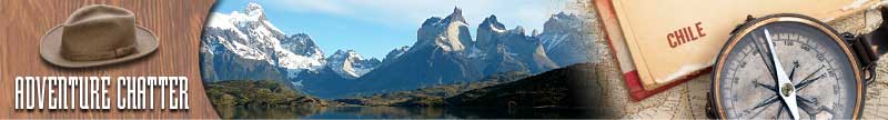
Torres del Paine National Park comprises mountains, glaciers, lakes and rivers. Located in southern Patagonia, it is a region of wild peaks, rushing rivers, icebergs, waterfalls, wildlife and varied flora. It is popular with adventure seekers, ecologists, scientists, environmentalists and photographers. Fishing, trekking, climbing, kayaking, hiking and nature walks are popular activities. Camping is allowed within the park. The Cordillera del Paine is the centerpiece of the park. It lies in a transition area between the Magellanic subpolar forests and the Patagonian Steppes. The pak is adorned with beautiful vegetation. Among them are the evergreen Embothrium coccineum, which produces vivid red flowers grouped in corymbs and the Calceolaria uniflora, of striking shape and colors. The national park is a popular hiking destination. There are clearly marked paths and many refugios which provide shelter and basic services. Views are breathtaking. Hikers can opt for a day trip to see the towers, walk the popular "W" route in about five days, or trek the full circle in 8-9 days. It is a national park and thus hikers are not allowed to stray from the paths. Camping is only allowed at specified campsites, and wood fires are prohibited in the whole park.
Radal Siete Tazas National Reserve is a nature reserve straddling the border between the provinces of Curico and Talca, Maule Region. It lies in a pre-Andean area close to Descabezado Grande volcano. The reserve's most popular feature is the area known as Siete Tazas (Seven Cups), which consists of seven consecutive natural pools with their respective waterfalls along Claro River. There are also two high waterfalls called El Velo de Novia (The Bridal Veil) and La Leona (The Lioness), with single vertical drops of 130ft and 65ft respectively. Here you find woods of mountain cypresses and oak trees, diverse species of singing birds like the thrush and the tenca; big predators like the puma and the colo-colo cat, and two marsupials - the yaca and the mountain monkey. There are also some scattered traces of old nomad villages whose inhabitants were hunters and harvesters, and where you can observe the remains of stone buildings used principally for the grinding of foodstuffs. The park is an attractive destination for kayakers, who can navigate the rapids of the Claro River.
Photography


If you have adventure-travel related experience in this region and would like to add content to this page, please contact us to learn how.