

General Information
| Languages : | Icelandic, English, Nordic languages, German widely spoken |
| Currency : | Icelandic Krona (ISK) |
| Time Zone : | EST +5hrs |
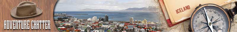
| Capital City : | Reykjavik |
| Population : | 0.3 Million |
| Government : | Constitutional Republic |
| Total Area : | 39,768 mi² |
| Climate : | Temperate; moderated by North Atlantic Current; mild, windy winters; damp, cool summers |
| National Holidays: | Independence Day, 17 June |
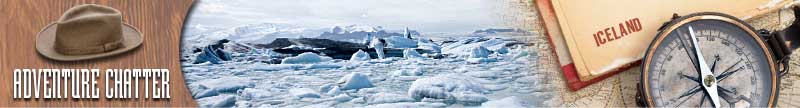
| Additional Info: | There are great icecaps and several glaciers, spouting geysers and steaming solfataras, dormant volcanoes, rivers and awesome waterfalls. You can also view a multitude of birds, and watch whales just offshore. |
Destination Activities
![]()
![]()
![]()
![]()
![]()
Activity Details
Ecotourism
Skaftafell National Park is situated between Kirkjubaejarklaustur, typically referred to as Klaustur, and Hofn in the south of Iceland. Today the park measures about 656 sq. miles, making it Iceland's second largest national park. There you can find the valley Morsardalur, the mountain Kristinartindar and the glacier Skaftafellsjokull (a spur of the Vatnajokull ice cap). Skaftafell is renowned in Iceland for its agreeable climate and the sunny days in summer, uncommon in the south of Iceland. There is a natural birch wood, Baejarstadarskogur, as well as many species of birds and arctic foxes. The waterfall Svartifoss (Black Fall) flows over a step of about 36ft. Its name comes from the black basalt columns behind it. The fall is surrounded by dark lava columns, which give rise to its name. The hexagonal columns were formed inside a lava flow which cooled extremely slowly, giving rise to crystallization. The base of this waterfall is noteworthy for its sharp rocks. New hexagonal column sections break off faster than the falling water wears down the edges.

Gullfoss (English: Golden Falls) is a waterfall located in the canyon of Hvita river in southwest Iceland. Gullfoss is one of the most popular tourist attractions in Iceland. The wide Hvita rushes southward. About 0.6 miles above the falls it turns sharply to the left and flows down into a wide curved three step "staircase" and then abruptly plunges in two stages into a crevice 105ft deep. The crevice, about 60ft wide, and 1.5 miles in length, is at right angles to the flow of the river. As one first approaches the falls, the crevice is obscured from view, so that it appears that a mighty river simply vanishes into the earth.

The Haukadalur valley lies to the north of the Laugarvatn in the south of Iceland. Here you will see some of the best sights of Iceland: the Geysers. The biggest geysers of Haukadalur are Strokkur and Geysir itself, which gave others their name. Strokkur is very dependable and erupts every 5 to 10 minutes, whereas the bigger Geysir only erupts 4 to 5 times a day. There are also a lot of other little hot springs nearby.
Hiking
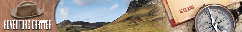
Due to its location on the Mid-Atlantic Ridge, Iceland is volcanically and geologically active on a large scale; this defines the landscape in various ways. The interior mainly consists of a plateau characterized by sand fields, mountains and glaciers, while many big glacial rivers flow to the sea through the lowlands. Because of the Gulf Stream, Iceland has a temperate climate relative to its latitude and provides a habitable environment and nature.
Skaftafell National Park in the south of Iceland is a popular spot for hikers. There are no roads in the park, but a network of trails offers the opportunity for extended hikes. The camping grounds are large but it is difficult to hammer the tent pegs into the gravel surface. Among the services in the park are toilets, washing machines, a restaurant, a small shop and a very interesting Visitors Center, where a comprehensive brochure with maps and hiking trails is available. The park wardens offer regular guided walking tours and a local Bus Company offers daily tours from the park to the volcanic Laki area as well as the daily schedule. This is one wonderful place to live: vast glaciers, ice-blue glacial lakes with silent icebergs, forbidding crevasses, mute peaks, jagged rocks, gulches, canyons, hanging valleys, shimmering ice tunnels, giant grotesque ice-arches, ice-falls, mountain torrents, roaring glacial rivers, ice-cold mountain streams flowing in ravines with luxuriant vegetation and wild flowers, waterfalls, basalt columns of most unusual configurations, rare birds and plants, birch forest, lush vegetation, and many other natural marvels have created this tellurian spectacle.

Lónsöræfi is a wilderness area in south-east Iceland. The region is characterized by its varied geological formations. These mostly date from a period 5-7 million years ago when the volcano Kollumulaeldstodvar was active. The glacier tongues of the eastern extreme of Vatnajokull also impose themselves on the area. Visible to the north-west is Snaefell (1833m), the highest peak in Iceland that isn't part of a glacier. Lónsöræfi, while less known and less accessible than areas such as Skaftafell and the Southern Highlands, is nevertheless popular with hikers. A transport service from Stafafell farm into the reserve via all-terrain bus is available. Alternatively, the recent construction of a bridge for walkers over the Jokulsa i Loni river at Eskifell has improved access for hikers. There are mountain huts at Geldingafell, Múlaskáli and Egilssel run by regional associations of Ferdafelag Islands. A 4-6 day walking route from Snaefell to Stafafell is possible via the Eyjabakkajokull glacier tongue. The area can also be reached from Geithellnadalur. The nearest settlements of any size are Hofn and Djupivogur.
Fishing
Iceland is a top spot for fly fishing, and unique to boot! Salmon and trout fishing are both popular. Although for salmon fishing, you need to get your permit well in advance, it's near impossible to get one on short notice. There are numerous lakes and rivers offering trout fishing and permits are easier to buy and less expensive than salmon fishing permits. For salmon fishing passes, it is best to work with a local company before your trip. The fishing season in Iceland starts in April on several sea trout rivers as well as a few lakes. The main lake fishing season starts in May, except for the highland lakes, which open in June. The season for the lowland lakes ends in September, and the highland lakes' season ends in August. The Salmon season starts in June and extends into mid-September. In a number of late-run rivers, fishing ends at the close of September. For some salmon rivers, the season ends on September 1st. The prime and highest-priced season is from mid-July until mid-August.
At the close of the last ice age, the island was completely covered by a thick ice sheet, which depressed large areas of the land below sea level. When the ice and snow melted, freshwater species expanded northwards and settled in Iceland. This is the main reason why fish are able to live in both sea and freshwater. There are five wild freshwater species to be found to be caught: Atlantic Salmon, Brown Trout, Arctic Char, Stickleback, and Ell. Wild brown trout and arctic char are the target species of game fishing in Icelandic lakes. The target species on rivers are wild salmon, brown trout, sea trout, char and sea char.
Photography


If you have adventure-travel related experience in this region and would like to add content to this page, please contact us to learn how.